SERVICES
Gadimaan Geo Survey Consultancy Pvt Ltd (GGCPL) offers a wide array of specialized Land Survey & Mapping services, leveraging the latest technologies to provide highly accurate, reliable, and detailed surveying and mapping solutions. GGCPL is known for its proficiency in handling complex surveying tasks for diverse infrastructure projects, including highways, tunnels, pipelines, canals, transmission lines, and more.
Key Surveying Services Offered by GGCPL:
Land Surveying & Mapping Services:
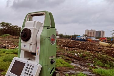
Total Station Survey: Precision land surveying using total stations for control surveys, boundary mapping, and setting out.
DGPS (Differential GPS): High-accuracy positioning for control surveys, improving GPS precision in challenging environments.
Drone Survey & LiDAR Survey: Advanced aerial surveying using drones for 3D mapping, topography, and LiDAR point cloud data collection. This technology is ideal for large-scale projects and areas that are difficult to access.
Building Layout / As-Built Survey: Accurate survey for existing buildings and infrastructure, including layouts and as-built documentation.
Road Survey: Surveying for road construction and alignment, including horizontal and vertical alignment, cross sections, and L-sections.
Canal & Transmission Line Survey: Surveys for water resources, irrigation, and power transmission projects, ensuring alignment and accuracy for long linear projects.
Detailed Topography & Alignment Surveys:
Topographic Survey: Comprehensive mapping of terrain for detailed planning, including elevation changes, natural features, and infrastructure.
Preparation of Horizontal and Vertical Alignments: For highways, tunnels, pipelines, canals, and transmission lines, providing detailed layouts and designs.
L-Section, Cross Section Creation: These sections are crucial for designing roadways, tunnels, and other linear infrastructure projects.
Specialized Monitoring & Surveying Techniques:
Settlement Monitoring: Monitoring and reporting of ground settlement, especially useful for tunnels, roads, and large infrastructure projects.
3D Monitoring: Using 3D models to track changes in terrain or structures over time.
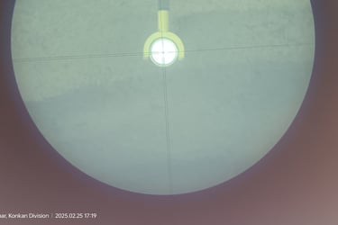
Tunnel Monitoring: Specialized surveys to monitor tunnel alignment, deformations, and ground conditions.
Landslide Zone Monitoring: Monitoring terrain shifts and identifying landslide risks in vulnerable areas.
Surveying for Construction Projects:
Horizontal and Vertical Control Traversing: For major projects like highways and tunnels, ensuring precise positioning of control
points across large distances.
Traverse Adjustment: Using high-accuracy software to adjust and correct survey data for improved precision.
Alignment Re-design: Adjusting and re-aligning roads and tunnels according to as-built surveys for any deviations or changes.
Survey Team Deployment: GGCPL offers dedicated survey teams on a monthly or yearly basis to support ongoing construction work.
Advanced Surveying and Mapping Technologies:
3D Point Cloud Mapping: Providing 3D representations of landscapes and structures, perfect for design and analysis in construction and engineering.
Digital Surface Models (DSM) & Digital Terrain Models (DTM): These models offer a detailed view of the surface and terrain, critical for environmental analysis, flood modeling, and infrastructure development.
Digital Elevation Model (DEM): A representation of the Earth's surface, valuable for flood risk assessment, drainage planning, and construction design.
Contour Maps: Detailed contour maps for terrain modeling, volume calculations, and site planning.
Volumetric Measurement & Cut/Fill Analysis: Essential for earthworks and excavation projects, providing calculations for cut and fill volumes.
Post-Processed Drone Video & Feature Markings: Enhanced drone footage for project documentation, showing key features and changes over time.
Survey Deliverables:
AutoCAD/GIS Drawings: Precise survey drawings in AutoCAD and GIS formats with feature markings for easy integration into design software.
Cross Sections and Long Sections of Land Profiles: Critical for understanding the design and construction needs of infrastructure projects.
Survey Reports: Detailed survey reports that include calculations, drawings, and analysis for stakeholders and clients.
Aerial Photography & Videography: High-quality images and videos for documentation, progress monitoring, and presentations.
GGCPL’s Commitment to Quality and Accuracy:
High-Accuracy Surveys: GGCPL employs cutting-edge technology to ensure the highest level of precision in all surveys.
Experienced Teams: GGCPL’s surveying teams have extensive experience across a wide range of sectors, including highways, tunnels, metro projects, and more.
Technology Integration: The use of drones, DGPS, LiDAR, and 3D mapping ensures that clients receive the most up-to-date and comprehensive survey data available.
Why Choose GGCPL for Surveying & Mapping:
Comprehensive Expertise: Over 10 years of experience handling large and complex surveying projects.
Advanced Technologies: Access to the latest drone, LiDAR, and GPS technologies to provide accurate, real-time data.
Tailored Solutions: Customized survey services to meet the unique needs of each project, ensuring the most efficient and cost-effective results.
Professional and Collaborative: GGCPL’s team works closely with clients to deliver high-quality results and meet project timelines.
By leveraging cutting-edge surveying technologies and a highly skilled workforce, GGCPL provides invaluable data and insights to clients across various sectors, ensuring the success of their infrastructure projects from conception to completion.
Land Survey & Mapping Services
Project Management Services
GGCPL’s Project Management services encompass all stages of the project, ensuring that every aspect is executed efficiently and effectively. The company’s expertise spans various sectors, including civil engineering, infrastructure, and construction, offering the following core services:
Integration Management:
Project Planning and Coordination: Ensuring that all project activities are aligned with the goals and objectives, integrating resources, timelines, and stakeholders.
Project Integration: Managing and harmonizing all aspects of the project to ensure seamless execution, tracking, and documentation of project phases.
Construction Supervision & Monitoring:
Construction Oversight: Supervising day-to-day construction activities, ensuring that work is carried out according to design, specifications, and project timelines.
Quality Control: Ensuring that construction materials, work processes, and deliverables adhere to the highest standards of quality.
Site Monitoring: Regular monitoring of project progress to identify delays, resolve issues, and mitigate risks before they escalate.
Time Management:
Project Scheduling: Developing and maintaining detailed project schedules using advanced project management tools.
Timely Delivery: Monitoring project progress to ensure all milestones and deadlines are met.
Adjustments and Re-Scheduling: Making necessary adjustments in case of delays to ensure the project remains on track.
Quality Management:
Quality Assurance (QA): Defining quality standards and ensuring that all work is carried out in compliance with these standards.
Quality Control (QC): Monitoring construction processes to identify quality issues early, ensuring compliance with quality standards at every stage.
Inspection and Testing: Ensuring that materials and construction methods meet the required specifications through regular inspections and testing.
Risk Management:
Risk Identification: Identifying potential risks to the project, including financial, environmental, and operational risks.
Risk Mitigation: Developing strategies to minimize or eliminate identified risks, ensuring the project stays on track.
Contingency Planning: Preparing backup plans for unforeseen issues to ensure minimal disruption to the project’s progress.
Scope Management:
Defining Scope: Clearly defining the project’s scope and objectives at the outset to prevent scope creep and ensure all deliverables are met.
Scope Control: Managing any changes to the project scope, ensuring that new requests are properly assessed and integrated without affecting the project’s overall success.
Cost Management:
Budgeting: Developing and maintaining a detailed project budget, including material costs, labor, equipment, and other expenses.
Cost Control: Monitoring expenditures to ensure the project remains within budget, identifying potential savings opportunities, and minimizing financial risks.
Financial Reporting: Providing regular financial reports to stakeholders to ensure transparency and accountability.
Structural Design Services:
We provide structural design for a wide array of construction projects, including buildings, tunnels, bridges, and other critical infrastructure. Our services cover every stage of the design process, from conceptualization and planning to the final construction phase, ensuring designs are not only safe but also cost-effective and optimized for performance.
New Structures: Comprehensive design solutions for new construction projects.
Evaluation and Renovation: In-depth analysis and structural evaluation of existing buildings to assess safety, capacity, and stability. We also specialize in renovation and repair of older structures.
Integration with Other Disciplines: Our structural designs are carefully integrated with those of other disciplines (e.g., electrical, mechanical, and civil engineering) to ensure seamless coordination during construction.
Structural Peer Review:
Peer Review Services: We offer peer review of structural designs, providing an independent assessment to ensure that designs are safe, code-compliant, and aligned with industry best practices. This is especially valuable for complex or high-risk projects.
Detailed Structural Analysis:
Our structural engineers use advanced software tools and analysis techniques to simulate and calculate the behaviour of structures under different loads, including static and dynamic forces. This allows us to ensure that structures can withstand environmental and operational stresses.
Supervision and On-Site Construction Support:
Construction Supervision: We offer site supervision and on-site support during the construction phase to ensure that all structural work is carried out according to the design specifications and in compliance with safety and quality standards.
Quality Assurance: Our team ensures that materials, workmanship, and construction processes adhere to the highest standards.
Key Structural Design Services Offered:
Residential Buildings: Design of residential complexes, high-rise buildings, villas, and apartments, ensuring comfort, safety, and aesthetic value.
Bridges: Structural design for road and railway bridges, pedestrian bridges, flyovers, and overpasses.
Tunnelling: Design and analysis of tunnels for metro systems, highways, and utilities, ensuring stability in challenging geotechnical conditions.
Commercial Buildings: Designing safe and functional commercial spaces, such as office buildings, retail centers, shopping malls, and business hubs.
Institutional Buildings: Designing institutional structures, including schools, colleges, universities, and government buildings, with a focus on functionality and safety.
Hospitals and Healthcare Facilities: Structural designs for healthcare infrastructure, ensuring patient safety and operational efficiency.
Hotels: Designing hotel buildings, from luxury resorts to business hotels, focusing on guest comfort and structural integrity.
Industrial Structures: Design of factories, warehouses, and manufacturing facilities, optimizing space utilization, load-bearing capacity, and operational efficiency.
Geotechnical and Structural Monitoring Services:
GGCPL’s monitoring solutions focus on real-time data collection, analysis, and reporting to ensure that potential issues are detected early, enabling timely interventions. This includes monitoring structural behaviour during both construction and post-construction phases to prevent damage and ensure long-term stability.
Key Infrastructure Monitored:
Bridges (New and Existing)
Railways & Metro Systems
Tunnels
Roads & Highways
Dams & Reservoirs
Buildings (Residential, Commercial, Industrial)
Landslide Zones and areas with geotechnical instability
Parameters Monitored:
GGCPL employs state-of-the-art instruments and advanced monitoring technologies to track a wide range of parameters. This ensures that every possible factor influencing the safety and stability of the structure is carefully measured and analysed.
Deformation and Settlement:
Settlement Monitoring: Detects vertical displacement, allowing early identification of potential subsidence or tilting in foundations.
Deformation Monitoring: Tracks changes in shape, structure, and alignment of bridges, tunnels, and roads.
Lateral Movement and Ground Movements:
Measures horizontal displacement of structures, monitoring lateral movements in response to external factors like vibrations or nearby construction activities.
Ground Movement Monitoring: Detects shifts in surrounding land that could affect structural integrity, especially in geotechnically challenging zones such as landslide areas.
Tilt and Inclination:
Tilt Monitoring: Tracks the tilt in structures like buildings, bridges, and tunnels to ensure they remain within safe operational angles.
Inclination Monitoring: Measures the tilt of elements such as walls, pillars, or structural beams to assess whether the building or infrastructure is under undue stress.
Displacement, Strain, and Stress:
Displacement Monitoring: Monitors relative movement between different parts of the structure to detect issues such as foundation shifts, cracks, or foundation settlement.
Strain and Stress: Measures strain in materials under pressure and the stress on critical components, such as beams, columns, and structural elements.
Load and Force:
Load Monitoring: Tracks the forces acting on structures, such as weight-bearing pressure on bridges, roads, or tunnels, to ensure that load-bearing components are functioning within safe limits.
Force Measurements: Determines the forces that affect structural elements during construction and in operational phases.
Vibrations Monitoring:
Vibration Analysis: Measures ground vibrations, especially in areas affected by traffic, construction, or heavy machinery. Vibrations can affect nearby structures, and continuous monitoring is essential for safety.
Seismic Activity: Monitors vibrations from external sources, such as earthquakes or nearby heavy traffic, which could affect the stability of sensitive structures.
Corrosion and Sour Assessments:
Corrosion Monitoring: Measures the rate of corrosion in structural elements such as steel reinforcements in concrete, which is critical for maintaining the long-term strength and durability of infrastructure.
Sour Assessment: Measures the chemical reactions occurring in soils or materials that might lead to structural deterioration over time.
External Environmental Influences:
Wind, Rain, Fog, Humidity, Temperature, and Traffic: Monitors environmental factors like temperature variations, rainfall, humidity, and wind conditions, which can influence the behavior of materials and structures.
Traffic Impact: Monitors how traffic loads affect bridges and roadways, including vibrations, strain, and stress from vehicular movement.
Water Monitoring:
Water Level and Water Pressure: Measures the water levels in dams, rivers, and water reservoirs to assess flood risk and structural safety under varying hydrological conditions.
Water Pressure: Monitors pressure exerted by water on underground structures like tunnels or dams, helping to identify potential water ingress issues or hydraulic pressures that may affect structural stability.
Technologies Used for Monitoring:
Bi-Reflective Target with Total Station: For precise deformation, tilt, and movement measurement of structures and landforms. This technology is ideal for real-time monitoring of bridges, tunnels, and roads.
Automated Monitoring Systems: Real-time data collection and remote monitoring with automated systems for continuous tracking and early warning.
GPS and DGPS Systems: High-accuracy GPS-based systems used for displacement monitoring and geodetic surveys, allowing for precise tracking of movements over time.
Inclinometer & Tiltmeters: These instruments measure small changes in angles, tilt, and slope, critical for monitoring structural alignment and stability.
Vibration Sensors: For real-time tracking of ground vibrations from traffic, construction, or seismic activity, ensuring infrastructure safety.
Strain Gauges and Load Cells: Installed on critical structural elements to monitor strain, stress, and load conditions, ensuring structures can withstand operational and environmental forces.
Environmental Sensors: Collect data on weather conditions, including rainfall, temperature, wind speed, and humidity, which may affect structural performance.
Corrosion Sensors: Special sensors that monitor the corrosion rates of materials, especially in infrastructure exposed to environmental elements or water.
Our Expertise in Structural Design & Engineering:
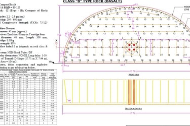
Drilling, Charging & Explosive Quantity Design in Tunnelling
We specialize in providing comprehensive Drilling, Charging, and Explosive Quantity Design services tailored for tunneling projects, including the following-
Precise Drilling Design
Accurate Charging Design
Controlled Blasting
Optimized Performance
Drilling Pattern Selection
Drilling Parameters
Charging & Explosive Quantity Design
Explosive Selection Based on Rock Type
Blast Design Optimization


